J Dent Rehabil Appl Sci.
2015 Dec;31(4):283-293. 10.14368/jdras.2015.31.4.283.
Geographic information system (GIS) analysis on the distribution of patients visiting at a dental college hospital: a pilot study
- Affiliations
-
- 1Department of Urban Planning, Graduate School, Hanyang University, Seoul, Republic of Korea.
- 2College of Dentistry, Dankook University, Cheonan, Republic of Korea. periopark@dankook.ac.kr
- 3Department of Urban Planning and Real Estate, Dankook University, Yongin, Republic of Korea.
- KMID: 2150192
- DOI: http://doi.org/10.14368/jdras.2015.31.4.283
Abstract
- PURPOSE
The aims of this study are to analyze and to visualize distribution of patients visiting at a dental college hospital, using geographic information system (GIS). The visualized data can be utilized in patient care and treatment planning, ultimately leading to the assessment of risk evaluation and prevention of dental diseases.
MATERIALS AND METHODS
Patient information data was obtained from Dankook University Dental Hospital including the unit number, gender, date of birth, and address from 2007 to 2014. Patient distribution was visualized using GIS. Statistical analyses were performed using SAS 9.3 and ArcGIS 10.1. Five factors including proximity, accessibility, age, gender, and socioeconomic status were investigated as the explanatory variables of the patient distribution.
RESULTS
The visualized patient data showed a nationwide scale of the patient distribution. There was a little difference in characteristics for each department. As closer at Dankook University Dental Hospital, visitors increased. And it strongly showed that elderly patients in rural areas tend to visit more.
CONCLUSION
The distribution of patients has been shown to be significantly affected by the proximity, accessibility, age, gender and socioeconomic status. The underlying reason remains to be further studied.
MeSH Terms
Figure
-
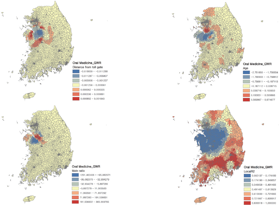
Fig. 1 Color coded local R-square of oral medicine.
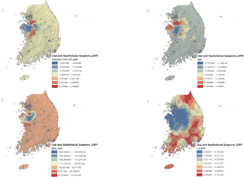
Fig. 2 Color coded local R-square of oral maxillofacial surgery.
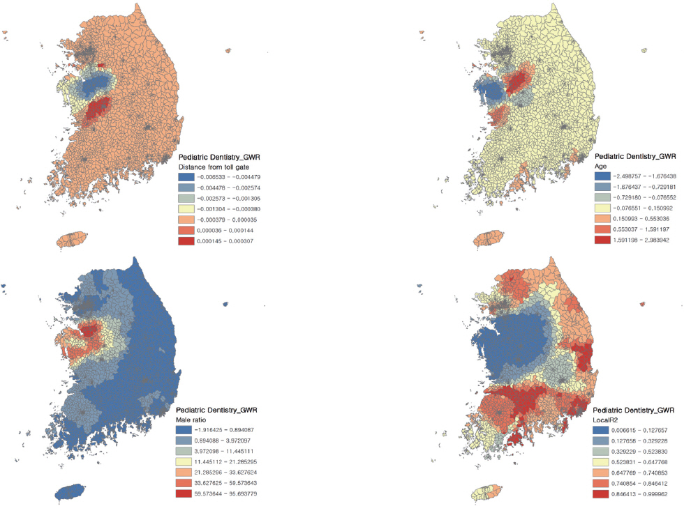
Fig. 3 Color coded local R-square of Pediatric dentistry.
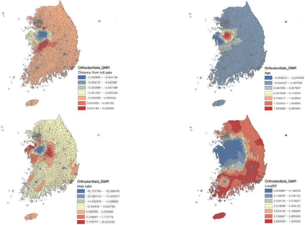
Fig. 4 Color coded local R-square of orthodontics.

Fig. 5 Color coded local R-square of conservative dentistry.
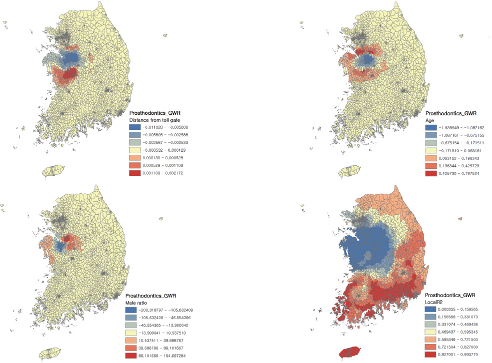
Fig. 6 Color coded local R-square of prosthodontics.

Fig. 7 Color coded local R-square of periodontology.
Cited by 1 articles
-
Geographic information system analysis on the distribution of patients visiting the periodontology department at a dental college hospital
Byungjoon Jeong, Hyun-Tae Joo, Hyun-Seung Shin, Mi-Hwa Lim, Jung-Chul Park
J Periodontal Implant Sci. 2016;46(3):207-217. doi: 10.5051/jpis.2016.46.3.207.
Reference
-
References
1. Horner MW, Mascarenhas AK. Analyzing location-based accessibility to dental services:an Ohio case study. J Public Health Dent. 2007; 67:113–8. DOI: 10.1111/j.1752-7325.2007.00027.x.2. Caprarelli G, Fletcher S. A brief review of spatial analysis concepts and tools used for mapping, containment and risk modelling of infectious diseases and other illnesses. Parasitology. 2014; 141:581–601. DOI: 10.1017/S0031182013001972. PMID: 24476672.3. Naves LA, Porto LB, Rosa JW, Casulari LA, Rosa JW. Geographical information system (GIS) as a new tool to evaluate epidemiology based on spatial analysis and clinical outcomes in acromegaly. Pituitary. 2015; 18:8–15. DOI: 10.1007/s11102-013-0548-3. PMID: 24368684. PMCID: PMC4297616.4. McGuire S, Kruger E, Tennant M. Travel patterns for government emergency dental care in Australia:a new approach using GIS tools. Aust Dent J. 2011; 56:389–93. DOI: 10.1111/j.1834-7819.2011.01371.x. PMID: 22126348.5. Sun W, Gong J, Zhou J, Zhao Y, Tan J, Ibrahim AN, Zhou Y. A spatial, social and environmental study of tuberculosis in China using statistical and GIS technology. Int J Environ Res Public Health. 2015; 12:1425–48. DOI: 10.3390/ijerph120201425. PMID: 25633032. PMCID: PMC4344675.6. Goli A, Oroei M, Jalalpour M, Faramarzi H, Askarian M. The spatial distribution of cancer incidence in fars province:a GIS-based analysis of cancer registry data. Int J Prev Med. 2013; 4:1122–30. PMID: 24319551. PMCID: PMC3843298.7. Kim YS. Development of emergency medical transprotation system using GIS (Geographic Information System). Korean J Public Health. 1996; 22:193–203.8. Lee HY, Park MY. Analysis of the emergency medical serviced area using GIS:the case of Seoul. J Korea Assoc Geogr Inf Stud. 2004; 12:193–209.9. Lee TS. Emergency medical system based on GIS. Korean Assoc GEO. 1996; 4:43–54.10. Shin H, Lee S. Factors affecting spatial distance to outpatient health services. Korean J Health Policy Adm. 2011; 21:23–43. DOI: 10.4332/KJHPA.2011.21.1.023.11. Joo SM, Lee KH, Choi JH. To identify the vulnerable areas of emergency medical services for Daegu city in 2012. J Daegu Gyeongbuk Dev Inst. 2012; 11:1–9.12. Tennant M, Kruger E, Shiyha J. Dentist-to-population and practice-to-population ratios:in a shortage environment with gross mal-distribution what should rural and remote communities focus their attention on. Rural Remote Health. 2013; 13:2518. PMID: 24098910.13. Derbi HA, Kruger E, Tennant M. Incidence of oral cancer in Western Australia (1982-2009):trends and regional variations. Asia Pac J Clin Oncol. 2014; Jun. 17. doi:10.1111/ajco.12205. [Epub ahead of print]. DOI: 10.1111/ajco.12205.14. Kim HJ, Hyun HK, Kim YJ, Kim JW, Jang KT, Lee SH, Hahn SH, Kim CC. A study of new-patient distribution and the motivies for visiting in the Department of Pediatric Dentistry at Seoul National University Dental Hospital. J Korean Acad Pediatr Dent. 2011; 38:25–32. DOI: 10.5933/JKAPD.2011.38.1.025.15. Park KL. An analysis on the characteristics of dental clinic distribution in Busan area using geographical information system. Kosin Med J. 2006; 21:108–18.16. Korean Statistical Information Service. Per capita personal income per administrative district. Available from: http://kosis.kr/statHtml/statHtml.do?orgId=101&tblId=DT_1C65. (updated 2015 Jul 6).17. Krishnatreya M, Saikia A, Kataki A, Sharma J, Baruah M. Variations in the spatial distribution of gall bladder cancer:a call for collaborative action. Ann Med Health Sci Res. 2014; 4:S329–31. DOI: 10.4103/2141-9248.141984. PMID: 25364614. PMCID: PMC4212402.18. Walker BB, Schuurman N, Hameed SM. A GIS-based spatiotemporal analysis of violent trauma hotspots in Vancouver, Canada:identification, contextualisation and intervention. BMJ Open. 2014; 4:e003642.19. Tennant M, Kruger E. Turning Australia into a ‘flat-land’:what are the implications for workforce supply of addressing the disparity in rural-city dentist distribution? Int Dent J. 2014; 64:29–33. DOI: 10.1111/idj.12059. PMID: 24460591.20. Tennant M, Kruger E. Building a stronger child dental health system in Australia:statistical sampling masks the burden of dental disease distribution in Australian children. Rural Remote Health. 2014; 14:2636. PMID: 25224399.21. Jo DG. GIS and geographically weighted regression in the survey research of small areas. Surv Res. 2009; 10:1–19.
- Full Text Links
-
- Actions
-
Cited
- CITED
-
- Close
- Share
-
- Similar articles
-
- Geographic information system analysis on the distribution of patients visiting the periodontology department at a dental college hospital
- Evaluation of Visiting Nursing Care Using Geographical Information System(GIS) Technology
- Geographical Information Systems and Health: Current State and Future Directions
- Spatial Distribution Analysis of Scrub Typhus in Korea
- Severity-Based Analysis of Prehospital Transportation Time Using the Geographic Information System (GIS)
